I-264 Corridor Evaluation Study July 2016
Final Report
Norfolk & Virginia Beach, Virginia Page I-1
I. INTRODUCTION
Interstate Route 264 (I-264) was originally designed to serve as the principal radial freeway spur
connecting the circumferential path of I-64 with the urban core of south side Hampton Roads.
While it has served as the main roadway facility for motorists accessing downtown Norfolk and
Portsmouth, its highest volumes do not occur within the circumference of I-64. Instead, the most
heavily traveled segment is located on a spur extending into the City of Virginia Beach that until
1999 was not part of the interstate freeway system.
I.1 History
From its interchange with I-64/I-664 in Chesapeake on the west end, I-264 provides high-
speed, limited access service for 25 miles to the freeway terminus to the east at Parks
Avenue in the Virginia Beach resort area. For this specific study the analysis focused on the
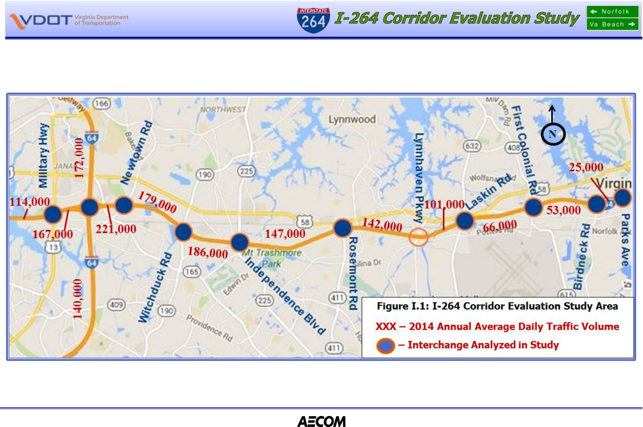
segments from the Military Highway interchange (Exit 13) in Norfolk to the freeway terminus
to the east at Parks Avenue - a distance of approximately 13 miles. (See Figure I.1: Study
Area). Between the interchange with I-64 (Exit 14) and Newtown Road (Exit 15) to the east,
I-264 carries the heaviest daily volume on any roadway in Hampton Roads. In contrast, its
easternmost segment - from First Colonial Road (Exit 21) to the eastern terminus - carries
relatively low volumes that move directly to and from a local street system that provides direct
driveway access to numerous residential and commercial parcels. Between these two
functional extremes, the freeway accommodates motorists at ten interchange locations.
I-264 was originally named the Virginia Beach-Norfolk Expressway. Numbered as Virginia
Route 44, roadway construction east of the Newtown Road interchange was financed through
bonds backed by toll revenue. It was opened in 1967 as a four-lane limited access highway,
and motorists were charged a mainline toll of 25 cents or an interchange toll of 10 cents.
Propelled by rapid residential and commercial suburban development during the 1970s and
1980s in the City of Virginia Beach, Route 44 volumes and revenues outpaced forecasted
levels, and by the 1980s it was undergoing improvements including a widening to six lanes
and the installation of an additional interchange at First Colonial Road. Traffic volume and toll
revenue growth continued into the early 1990s, when the roadway was widened to its current
width of eight lanes to the west and six lanes to the east of First Colonial Road. With the
revenue reserve exceeding the outstanding debt, the bonds were redeemed and the tolls were
removed in 1995.
High Occupancy Vehicle (HOV) restrictions were brought to Route 44 in the early 1990's. HOV
restrictions became a permanent part of the roadway. However, the shoulder lane was
improved and designated to accommodate volumes during the periods when HOV restrictions
were in force. As a result, the roadway provides eight lanes to conventional traffic volumes at
all times in addition to the directional, concurrent flow HOV lanes during peak hours. With the
addition of direct access to the reversible flow HOV lanes on I-64 to the west in Norfolk, Route
44 was fully integrated into the Hampton Roads freeway system. In 1999, it was accepted
into the federal interstate highway system as an extension of I-264.
I.2 Function
I-264 still functions to meet its two original purposes: a direct access route for tourists to the
resort area of Virginia Beach and a high volume access route to employment centers for
commuters. Since 1967, the characteristics of the former have changed only in magnitude
while those of the latter have evolved with changing economic and cultural patterns. The only
two major employment centers in southside Hampton Roads in 1967 were the Norfolk Naval
Station complex and the downtown areas of Norfolk and Portsmouth (including the Norfolk
Naval Shipyard in Portsmouth). By 2002, these two centers were joined by several others,
most of which were located in the suburban areas of Chesapeake and Virginia Beach. The
movement of economic activity to suburban settings included the retail commercial sector with
the opening of major retail centers. All the major centers in Virginia Beach were located in
close proximity to an interchange on I-264.
The changing landscape along the corridor produced commensurate changes in the magnitude
and patterns of vehicle trips. The addition of commercial, institutional and freight traffic to the
heavy number of commuter vehicles by the year 2014 produced daily volumes approaching a
quarter of a million vehicles at the Newtown Road interchange. Since I-264 opened in 1967,
the number of lanes on it has doubled while the volume of vehicles has increased more than
tenfold. Moreover, while the direction of peak flows remains westbound in the morning and
eastbound in the afternoon, the contraflow volume has steadily increased in both numbers and
proportion. On both eastbound and westbound oriented ramps, peak hour traffic at
interchanges has increased to where congestion is a daily occurrence. The most severe
congestion occurs at the following five interchanges: I-64, Witchduck Road, Independence
Boulevard, Rosemont Road and Lynnhaven Parkway.
I.3 Enhanced Resources for Funding Improvements
1
In 2013, a transportation funding package entitled “Virginia’s Road to the Future.” was signed
into law. HB2313 (2013 Virginia Acts of Assembly, Chapter 678) included statewide and
regional funding mechanisms to help address Virginia’s transportation funding shortfalls. The
regional provisions impose certain state taxes in the localities comprising Planning District 23,
establishing two new revenue streams for transportation in Hampton Roads deposited into a
newly established Hampton Roads Transportation Fund (HRTF) effective July 1, 2013.
Effective July 1, 2014, HB1253/SB513 amended the section of the Code of Virginia regarding
the HRTF and created the Hampton Roads Transportation Accountability Commission (HRTAC)
to manage the HRTF revenues for Hampton Roads. The Commission is responsible for
determining how the new regional money will be invested in transportation projects in
Hampton Roads.
1
HRTAC Guidebook: Updated July 2015. Hampton Roads Transportation Accountability Commission.
I-264 Corridor Evaluation Study July 2016
Final Report
Norfolk & Virginia Beach, Virginia Page I-2
Note: Daily traffic volumes are presented for informational purposes only. Analysis has been
conducted using peak hour volumes, which are documented later in this report.
VDOT is the source of the Annual Average Daily Traffic volumes (AADT).
I-264 Corridor Evaluation Study July 2016
Final Report
Norfolk & Virginia Beach, Virginia Page I-3
I.3.1 Hampton Roads Transportation Fund (HRTF) Revenue
In addition to the HB2313 taxes and fees imposed statewide, the HRTF revenues are estimated
generate an additional $170 million on average annually for transportation projects in Hampton
Roads through a dedicated gas tax and an increase in the regional sales tax. As provided for in
the legislation (§ 33.1-23.5:4.), which states: “The moneys deposited in the Fund [HRTF] shall
be used solely for new construction projects on new or existing highways, bridges, and tunnels
in the localities comprising Planning District 23, as approved by the Hampton Roads
Transportation Accountability Commission. The Hampton Roads Transportation Accountability
Commission shall give priority to those projects that are expected to provide the greatest
impact on reducing congestion for the greatest number of citizens residing within Planning
District 23 and shall ensure that the moneys shall be used for such construction projects.”
HRTF revenues are derived from an additional 0.7% sales and use tax, as well as an additional
2.1% sales tax on motor fuel in the subject 14 Hampton Roads localities:
• Additional Sales Tax Increase: The sales tax in Hampton Roads increased an
additional 0.7% on top of the 0.3% statewide increase, bringing the total sales tax
on purchases made in Hampton Roads to 6%.
• Additional Fuels Tax: The wholesale tax on motor fuels was boosted by an
additional 2.1% beyond the statewide level for Hampton Roads.
I.3.2 Candidate Projects
While HRTAC is responsible for managing HRTF revenues, the development of candidate
projects to which these funds can be allocated is assigned to the Hampton Roads
Transportation Planning Organization (HRTPO), the regional metropolitan planning organization
(MPO) for transportation planning. During the September 19, 2013 meeting, the HRTPO Board
approved a resolution endorsing the identification of Fund revenue to fund regionally
significant projects. In addition, the HRTPO Board directed the HRTPO staff to develop a list of
HRTF candidate projects.
Starting with projects included in the 2034 Long-Range Transportation Plan, the list of
candidate project was developed using the following criteria:
a. Regionally Funded Construction Projects
b. Ongoing Studies
c. Unfunded Projects for Future Consideration
d. Eligible for funding under the provisions of HB2313
e. Minimum project cost threshold = $100 million
The resulting HRTF Candidate Projects were:
• I-64 Peninsula Widening (6-Lane Option): Three segments from Jefferson Avenue
(Exit 255 west to Route 199 West of Williamsburg (exit 234).
• Hampton Roads Multi Modal Third Crossing: Widening of I-664, and construction of
the Craney Island Connector and Patriots Crossing.
• I-64 Southside Widening, I-464 to I-664 at Bowers Hill, including the High Rise Bridge.
• I-64/I-264 Interchange: I-64 Westbound to I-264 Eastbound through the Witchduck
Road Interchange.
• US Route 460/58/13 Connector: I-664 at Bowers Hill to the eastern end of the Suffolk
Bypass.
For consideration in this study, the key candidate project is the I-64/I-264 Interchange, which
provides for improvements on eastbound I-264 between I-64 and Witchduck Road. These
improvements – phased in two separate projects - have been under design and right of way
acquisition. Fully funded, construction is scheduled to start on the first phase in summer of
2016. While funds for construction of the second phase (between the Newtown Road and
Witchduck Road interchanges) have not yet been programmed, they are expected, and
construction is scheduled to start later in 2016. Without the funds that have been made
available through HRTF, construction for both of these projects would likely be on hold.
I.4 Previous Studies
In 2001, VDOT executed the design contract for widening the ramp from westbound I-64 to
eastbound I-264, and the first task of this contract was to study the I-264 corridor.
Conducted in cooperation with The Federal Highway Administration (FHWA) and the cities of
Norfolk and Virginia Beach, the study was structured to develop recommendations to ensure
that anticipated improvements at various interchanges would be implemented as part of a
coordinated corridor improvement plan. As stated in the study report:
The purpose of this study is to identify appropriate improvements to the facility
to adequately accommodate forecasted mainline freeway traffic volumes. Once
adopted, the plan for improvements to the I-264 freeway lanes will serve as a
guide in the design of improvements to the interstate.
In addition to developing recommended improvements to the mainline freeway, the corridor
study addressed improvements at several interchanges on I-264, including Newtown Road and
Witchduck Road. Improvement concepts at these two interchanges were developed to
address existing and forecasted capacity deficiencies, as well as existing geometric deficiencies
in the eastbound direction only.
VDOT and FHWA recognized funding constraints would mandate that recommended
improvements be implemented in a phased approach. To accommodate phased
implementation, FHWA stipulated that individual improvement projects must exhibit
independent utility. That is, the improvements proposed in any individual project must - as a
stand-alone improvement - produce benefits to the motoring public.
I-264 Corridor Evaluation Study July 2016
Final Report
Norfolk & Virginia Beach, Virginia Page I-4
On November 22, 2006, FHWA accepted the
I-264 Corridor Study Final Report
. In her
communication to VDOT, FHWA Area Engineer Vanna Lewis stated:
... this will confirm that the Final Report is accepted by FHWA. As noted in your
cover letter to the Final Report (received 28th June 2006), it is expected that the
two current I-264 design projects, and any/ all future design projects on I-264
east of I-64 will be based upon (or rather, have as their “starting point”) the
conceptual design set forth in this Study.
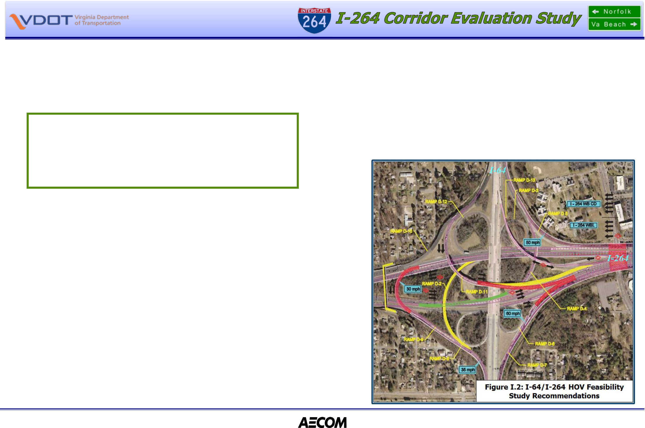
Prior to the I
-264 Corridor Study Report (2006),
the interchange of I-64 with I-264 had been
analyzed for the purpose of extending the HOV lanes on I-264 through the interchange area.
Currently, HOV lane restrictions end prior to entering the interchange and are re-established
after passing though. The restrictions are discontinued because at three locations general-
purpose ramps merge with or diverge from the median (left) lane. Maintaining the HOV
restrictions would effectively prohibit general-purpose traffic from using these ramps. The
analysis and recommendations were documented in the report,
I-264 HOV Feasibility
Study
(VDOT, January 23, 1997).
The study recommended a three-step method for extending the HOV lanes by moving three
ramps (See Figure I.2: I-64/I-264 HOV Feasibility Study):
1. In the westbound direction, the left exiting ramp from the mainline I-264 lanes to
eastbound I-64 (Ramp D-2) is relocated to the outside Mainline I-264 lane;
2. In the eastbound direction, the left exiting ramp to westbound I-64 (Ramp D-4) is
removed and replaced with a ramp the exits from the outside eastbound I-264
mainline lanes; and,
3. In the southbound direction (eastbound I-64), relocation of the junction of the flyover
ramp with the outside eastbound I-264 mainline lanes.
These three improvements to the I-64/I-264 interchange serve as a starting point for
developing improvements to the I-264 corridor to the east.
The most recent study focused on the specific improvements programmed for the I-64/I-264
interchange. Documented in the report: I-64/I-264 Interchange Modification Report
(June 2011), the study analyzed improvement to the existing single lane ramp from
westbound I-64 to eastbound I-264 (interchange Ramp D-7). The purpose of the ramp
widening is to provide additional capacity to accommodate vehicles making this movement,
and thereby to eliminate prolonged periods of congestion and to reduce high frequency of
crashes associated with congestion. The study
(I-64/I-264 IMR
) was a more detailed analysis,
and was required by both FHWA and VDOT prior to beginning detailed design of
improvements to interstate interchanges. It should be noted that the
I-64/I-264 IMR
process
uses the
I-264 Corridor Study (2006)
as a starting point for developing improvement
alternatives. Although the final Preferred Alternative recommended in the
I-64/I-264 IMR
varied from the preferred alternative in the
I-264 Corridor Study (2006),
it did address all of
the deficiencies documented in the 2006 study, and - most importantly – the Preferred
Alternative was designed to accommodate other corridor improvement recommended in the
2006 study.
The I-264 Corridor Study
(2006) did not
analyze all movements at the I-64/I-264
interchange. No comprehensive planning level
analysis of the entire interchange had been
conducted prior to this study.

I-264 Corridor Evaluation Study July 2016
Final Report
Norfolk & Virginia Beach, Virginia Page I-5
I.5 Study Purpose
Recognizing that in addition to HRTF, additional funding for transportation improvements in
Hampton Roads may potentially become available through state funds and/or debt financing,
VDOT, in coordination with the cities of Norfolk and Virginia Beach, initiated this study to
develop a comprehensive corridor framework for future corridor improvements. While this
study has updated the roadway and interchange analysis previously in 2006, it has expanded
the boundaries from that study to include the Military Highway, First Colonial Road and
Birdneck Road interchanges. It also includes all movements at the I-64/I-264 interchange.
The purpose of this study mirrors that of the 2006 study: “…to identify appropriate
improvements to the facility to adequately accommodate forecasted traffic volumes (and)…to
serve as a guide in the design of improvements to the interstate.” However, with the potential
for additional funding through HRTAC, a second purpose of this study is to provide both VDOT
and HRTAC with costs of improvements that may be considered for programming.
While providing an overall framework for improvements to the corridor, the recommendations
set forth in this study should not be viewed as a unified, rigid set of improvements, nor should
the costs be viewed as program in need of a comprehensive financing plan.
The framework developed herein is the product of a planning level analysis. More detailed
analysis of all proposed interchange improvements (specifically, interchange modification
reports and environmental documents) must be completed before design can begin.
Moreover, this study does not address the relative priorities among the interchange
improvements. Setting such priorities will be completed as part of the regional transportation
planning and programming process.
I.6 Study Elements
Following this introduction, Section II presents the methodology for conducting the technical
analysis. Next, beginning with the Military Highway interchange, sections III-XIII document
the analysis of each interchange, describing the deficiencies to be addressed, the alternatives
to address them and the basis for the recommendation of the preferred alternative. This
report closes with Section XIV, which presents a summary of the study findings and
recommendations.
It should be noted that each interchange east of and including Military Highway was analyzed
with the exception of the Lynnhaven Parkway interchange. The Lynnhaven Parkway
interchange had been previously analyzed and a preferred improvement alternative had been
recommended and accepted by both VDOT and FHWA. Furthermore, the first phase of the
interchange improvements has been implemented with the installation of two ramps (an
eastbound I-264 off ramp and a westbound I-264 on ramp) intersecting with London Bridge
Road between Potters Road and Virginia Beach Boulevard.
Since the improvement plan for the Lynnhaven Parkway interchange had been accepted and
implementation had been initiated, it was determined that additional analysis to meet the
intent and purpose of this study was not needed. It should be noted that the proposed
improvements to the Lynnhaven Parkway interchange are depicted in graphic shown later in
this report.
