Directions
This page includes directions and key information that should be useful for first-time travelers
planning a trip to Training Center Yorktown, Virginia. It includes specific directions you'll need
to get to the base and information about commercial transportation.
Arriving from the north
Directions are provided for primary routes for people coming from the vicinity of Washington,
Richmond, Norfolk, and other major points. The major roads/routes described in the directions
are displayed in the appropriate maps section.
Coming from Washington or Richmond via I-64
I-64 is typically the fastest way to travel from Richmond to the Yorktown area. Most travelers
driving from Washington (or other points north) drive south from the Washington DC area on
I-95 South to I-295 South (bypasses Richmond) to I-64 East. Route steps once you are on I-
64 East are:
1. Take I-64 to Fort Eustis Blvd - Yorktown Exit (Exit 250-B).
2. Proceed 3 and 3/4 miles on Fort Eustis Blvd to traffic light. Turn left on to Route 17
North (George Washington Memorial Highway).
3. Proceed about 3/4 of a mile to second traffic light and turn right onto Cook Rd.
4. Proceed approximately 2 and a 1/2 miles to the "STOP" sign and turn right on to Route
238 East.
5. Follow Route 238 for approximately 1 and a 1/4 miles to the TCYorktown gate.
Coming from points north via Route 17
Travelers arriving from the north via Route 17 can use the following directions:
1. Follow Route 17 South across the Coleman Memorial Bridge.
2. Proceed approximately 1/4 mile past the bridge and turn left on Route 238 East.
3. Follow Route 238 for approximately 2 miles to the TCYorktown gate.
Arriving from the south
Most travelers will cross over to the Peninsula via the James River Bridge (Route 17 North),
the Monitor-Merrimac Memorial Bridge Tunnel (I-664), or the Hampton Roads Bridge Tunnel
(I-64 West). The major roads/routes described in the directions are displayed in the
appropriate maps section. Directions to TCYorktown these areas are:
From the James River Bridge (Route 17 North)
1. Route 17 North turns left about 3/4 miles after crossing the James River Bridge and
becomes Jefferson Ave/Route 143.
2. Follow Jefferson Ave (Route 17 North) for approximately 4 miles and turn right on to J.
Clyde Morris Blvd.
3. Follow J. Clyde Morris Blvd (Route 17 North) for approximately 10 miles (it will
become the George Washington Memorial Highway when you cross into York County)
until you reach Cook Road.
4. Turn right onto Cook Rd.
5. Proceed approximately 2 and a 1/2 miles to the "STOP" sign and turn right on to Route
238 East.
6. Follow Route 238 for approximately 1 and a 1/4 miles to the TCYorktown gate.
Coming from points south via I-64 or I-664
1. From I-664. Cross over on to the Peninsula via I-664 and continue until you reach I-64
in Hampton. and continue with directions as noted below.
2. From I-64. Follow I-64 (west) toward Yorktown/Williamsburg.
3. Take I-64 to Fort Eustis Blvd - Yorktown Exit (Exit 250-B). At the bottom of the ramp,
turn left, then right onto Fort Eustis Blvd.
4. Proceed 3 and 3/4 miles on Fort Eustis Blvd to traffic light. Turn left on to Route 17
North (George Washington Memorial Highway).
5. Proceed about 3/4 of a mile to second traffic light and turn right onto Cook Rd.
6. Proceed approximately 2 and a 1/2 miles to the "STOP" sign and turn right on to Route
238 East.
7. Follow Route 238 for approximately 1 and a 1/4 miles to the TCYorktown gate.
Arriving by Commercial Modes
Bus
The nearest Greyhound Bus Terminal is located in Newport News; 10 miles from TCYorktown.
There is no commercial (local or long-haul) bus service directly to the base.
Taxi/Limo
Fares vary widely from local/regional bus, rail, and airport terminals. Some typical
local/regional fares are provided in the following table. Costs are subject to change on short
notice.
Arrival Point Ground Transportation
Newport News/ Williamsburg Airport
(757) 877-0221
Associated Cabs, Inc. (757) 887-3412/3322
Yellow Cab. (757) 855-1111
Yorktown Shuttle. (757) 890-2840
Williamsburg Limo & Shuttle. (757) 877-
0279
Norfolk International Airport
(757) 857-3351
Norfolk Airport Express (757) 857-5950
Richmond Airport
(804) 226-3000
Groome Trans. Service (800) 552-7911
Amtrak Train Stations
Stations in Richmond, Williamsburg,
Newport News, and Norfolk
Associated Cabs, Inc. (757) 887-3412/3322
Yellow Cab. (757) 855-1111
Newport News Greyhound Terminal
(757) 872-4405
Associated Cabs, Inc. (757) 887-3412/3322
Yellow Cab. (757) 855-1111
Railroad
AMTRAK provides daily service from all major cities in the U.S. to: Newport News,
Williamsburg, Norfolk and Richmond.
Air
Three airports service the southeastern Virginia Area. They are listed in the following table by
preferred order of use, descending from most desirable to least.
Airport Location Distance from base
Newport News/ Williamsburg
Airport
(757) 877-0221
Newport News, VA 12 miles
Norfolk International Airport
(757) 857-3351
Norfolk, VA 35 miles
Richmond Airport
(804) 226-3000
Richmond, VA 50 miles
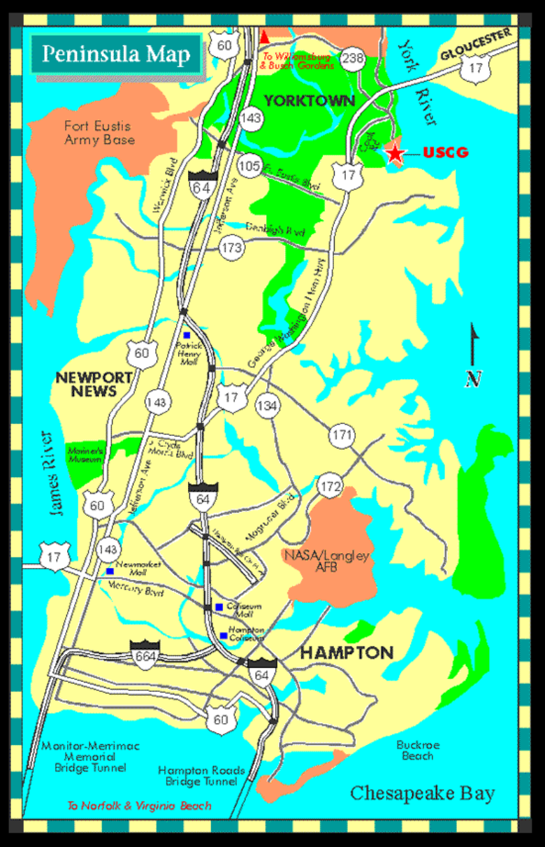
Virginia Peninsula Regional Map
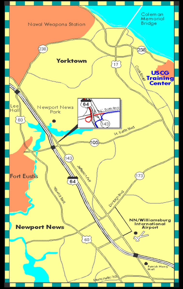
Yorktown Regional Map
